Navigation 06
OPENING QUESTION:None Today
LEARNING TARGET: I will practice using VOR-like navigation tools during today's class
WORDS O' THE DAY:
- Navigation: ("controlling the movement of a plane from one place to another")
- Dead Reckoning ("Navigation where you head in one direction at a particular speed for a certain length of time and hope you end up where you want to")
- Air Traffic Control - ATC
- VFR ("Visual Flight Rules" - The most basic 'rating' a pilot earns. VFR means you are ONLY allowed to fly when conditions are very good and you can see everything you need to see to EASILY navigate from one place to another WITHOUT having to use your navigation instruments.
- IFR ("Instrument Flight Rules" - The next most important 'rating' a pilot earns. IFR means you are allowed to fly in weather that does NOT allow you to see to navigate. In other words, you can navigate by instrumentation ONLY
- VOR
WORK O' THE DAY:
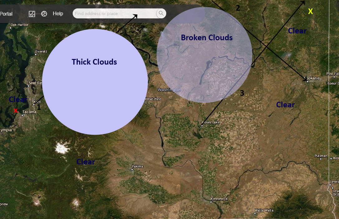
Consider the following map:
═══════════════════════════
Work for today:
1) Download that picture
2) Print the picture (if you have a printer - B/w is fine)
3) If you or someone at home has a smartphone - download a protractor application (there are a number of very good ones) that use the camera on your phone
4) Note that there are 3 "Radials" (lines in black)
5) Identify where each radial is going out from a particular city or going in towards a particular city
6) Use the protractor app to measure the angle of each of those "Radians"
Work for Tomorrow:
Imagine you need to fly from Gig Harbor (The Tacoma Narrows Airport) shown with an x on the map above.... way over to the northeast corner of our state shown with an X
1) Identify the part of your trip where you will definitely have to use IFR rules
2) Identify the part of your trip where you will definitely use VFR rules
3) Identify the part of your trip where you may have to use IFR rules
4) Write a "flight plan" to show how you will fly to your destination using those VOR "radials"
Be Prepared to Discuss/Submit your work on Friday